Showing posts with label Valais. Show all posts

Saturday, 20 June 2015

Go with the flow - follow the bisse...


Vercorin Bisse
Within the Valais there are over 2000km of 'Bisse' - as they're called in French, and Wasserleite or Suonen in German. These ancient, man-made water channels, traverse the mountains, bringing valuable water from rivers to villages and fields. Once they were a life-line, but after WWII many fell into disuse and disrepair as technology advanced, and the cost of maintaining them rose.
Paddles and locks control the flow of the water along the Vercorin Bisse
Today, many have been restored and you can walk the well graded paths next to the channels. Here, in the Val d'Anniviers, there are several dotted around (although not all have water). Vercorin is a favourite - through forest, and around the hill into the Vallon de Réchy. It's a great walk, and on a hot day the water acts as a natural air-conditioner below the trees. Elsewhere in the Valais, there are more 'sporting' routes, such as the Torrent-Neuf above Savièse. A great example of the risks and feats of engineering that were achieved to get water to where it was needed.
Torrent-Neuf, Saviese
The Torrent-Neuf dates back to 1430, with many extension and even tunnels added over the centuries. It has recently been restored and is open to walkers between May and November. But you need a good head for heights -  bouncy new suspension bridges, link cantilevered sections of boardwalks across the tall cliff face. An amazing route, and the information panels with old photos show just how dangerous this was to build and maintain: www.torrent-neuf.com

For more hiking routes that follow bisse in the Valais:
www.valais.ch/en/activities/hiking/bisses
www.valrando.ch/bisses1/propositionsbisse.php

The Museum of bisses is in Anzère:
www.musee-des-bisses.ch/musee-bisses

Some wonderful old footage of a 'guardian' of the bisse at work:
www.rts.ch/archives/tv/information/3441605-le-gardien-du-bisse.html

Sunday, 19 April 2015

Rule Britannia

The Britannia Hutte at 3030m
Paid for by the British members of the Swiss Alpine Club, the Britannia Hutte first opened in 1912, and was given to the SAC in thanks for the hospitality British mountaineers had always received. One hundred years on and the connection is still strong. For the centenary anniversary the British members bought the hut seven new solar panels.
Starting out to summit the Strahlhorn 4190m
Today the Britannia Hutte isn't just popular with the British in fact its the most popular hut run by the SAC in the alps. Why? As they say it's location, location, location. So close to Saas Fee (in winter ski tourers can use the lifts almost to the door - it's just a 15 minute slide and walk from the top of the Egginerjoch drag lift), and it's so close to some stunning mountains. From the hut you can summit the Strahlhorn 4190m, Fuchthorn 3795m, Rimpfischhorn 4198m, Alphubel 4206m,  Allainhorn 4027m and join the Haute-Route ski tour. And don't forget those amazing sunsets.
Stunning sunsets
But the accommodation and food is also top notch. Having undergone an extension and renovations in 1997, it can comfortably sleep 134, has 3 dining rooms, indoor loos and running water and is run by a small, extremely cheery team who work from before 5 am to gone 10pm each day. It's popularity with guides may be down to the free pre-dinner glass of wine.

One of the three dining rooms


The hut is open for ski tourers from March-May, and for summer mountaineering and climbing from middle of June to end of September. To book visit the website www.britannia.ch


Saturday, 9 August 2014

Riding the Rhone

Cycling through the vineyards
Cycling around Zinal can be hard work - it's either sweating slowly up or a white knuckle descent which leaves your hands aching from braking so hard. For an easier day out, we head down to the main valley to follow one of the many cycle routes.
SwitzerlandMobility covers the whole country - road & mountain bike, walking, inline skating and even canoe routes. The app gives you the country's best mapping for free as well.
Plenty of mapping and signs
Many of the road bike routes are mostly traffic free tarmac and wind through the valley's fruit orchards and vineyards with occasional detours into small villages. Best to head out to the west through the vineyards and villages and then get blown back along the perfect path beside the Rhone by the prevailing winds. In the event of breakdown - you or your bike - you can always just hop on the train to get back to where you started.

Routes through hill villages and orchards
From the upper Valais it's possible to follow the Rhone all the way to the Mediterranean - perhaps the ultimate summit to sea trip - use the SwitzerlandMobility site for the swiss leg then www.viarhona.com for info on the journey through France.

Routes and mapping:
www.veloland.ch/en/cycling-in-switzerland.html
www.lacyclosportivevalaisanne.ch

Rent a bike for an afternoon or two
www.valaisroule.ch/fr/velospot.html
www.rentabike.ch/?dsmid=113360&action=viewdet&id=542
www.veloland.ch/fr/services/location-de-velos-et-e-bikes-0641.html
www.publibike.ch

Saturday, 31 May 2014

Top 100

This is the 100th post on this blog so it seems appropriate to list (in no particular order) some of our favourite things to see, do and experience in and around the Val d'Anniviers

Things to see: 

Black-nosed sheep, gentians and edelweiss.
  • Patch of gentians
  • Black-nosed sheep
  • Ptarmigan
  • Edelweiss
  • Sunset on the Besso
  • Crocus poking up through the snow as spring arrives
  • Meadows of summer flowers
  • Marmotts running across the fields
  • Ibex on the cliffs
  • Waterfalls beyond Zinal in spring
  • Golden Eagles
Walking routes:
Tour lac de Moiry, Lac Noir and up to Cabane d'Arpitettaz
  • Up to Cabane d'Arpitettaz 
  • Wiesshorn hotel to Zinal
  • From top of Sorebois lift to Cabane Petit Mountet 
  • Tour lac de Moiry
  • Bisse walk in Vercorin
  • Descent of Vallon de Rechy
  • Crete de Midi
  • Up to Cabane Grand Mountet
  • From Bendolla south to the dam
  • Chandolin along the cliffs
  • Lac noir above St Luc
Best events:
Feeries Christmas Market, Sierre-Zinal race
  • 1st August fireworks in Zinal
  • Feeries Christmas market Grimentz
  • Friday markets in August Grimentz
  • Sierre Zinal mountain marathon
  • Vercorin jazz festival
  • Grimentz three day classical music festival 
  • Marche des Cepages, wine and walking tour though the vin-yards
  • Desalps
  • Grand Raid – Verbier to Grimentz mountain bike race 
Food & Wine:
Locally cured sausages, home-made redcurrant jelly
  • Fresh serac cheese from the alpine diary
  • Vin de glacier from Bourgeois Grimentz
  • Myrtle tart at Hotel Wiesshorn
  • Wild alpine strawberries 
  • Multi-grain bread from Salamin bakery
  • Local cured dried sausages
  • Redcurrant jelly made from the wild berries around the house
  • Glass of white wine from the caves of Sierre
Favorite pistes to ski:
Illhorn red piste, Chandolin
  • Chamois, Zinal
  • Pas de Beouf to Prillet, St Luc
  • Vercorin blue, from top station to the village
  • Blue from Grands Plans chair past Etable du Marais, Grimentz
  • Illhorn red piste, Chandolin
Things to do and visit:
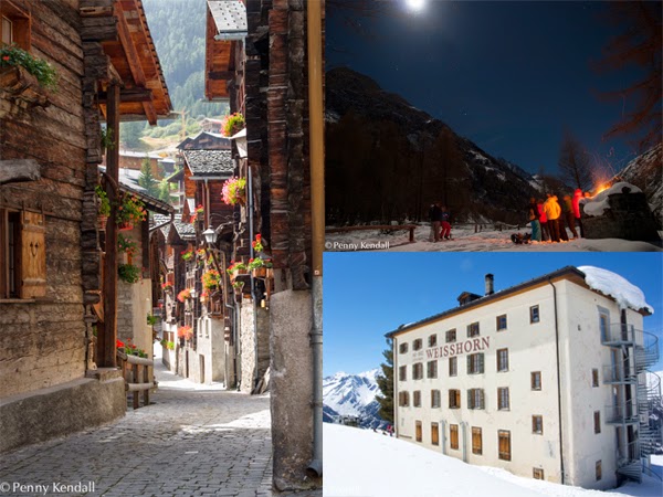
Grimentz old town, moon light walk in winter, Hotel Weisshorn
  • Histoic house, Zinal
  • Walk through Zinal old town
  • Centre of Grimentz
  • Moon light walk in winter
  • Sleep out under the stars on a summer's night
  • Visit old flour mill in Grimentz
  • See cheese being made in the mountain dairies
  • Star gaze from the St Luc observatory
  • Visit hotel Weisshorn – even better stay overnight
  • Visit Tzoucdana cafe and see the farm animals
  • Overnight in a mountain hut 
  • Via ferrata below Moiry dam
  • Snow shoe to the snout of the Zinal glacier and discover the ice-cave
Best off piste:
Down to the dam
  • Down to the dam from Zinal
  • Orzival
  • Vallon de Rechy
  • Variants around Chamois
  • Off back of St Luc into Turtmann valley
  • Zinal free-ride zone
  • Vercorin trees
  • Lona
  • Pylon route 
  • Middle bowl, Zinal
  • Abondance
  • Trees to Chiesso Blanc
Views to see:
Weisshorn, glaciers above Grand Mountet, sunset from Tracuit
  • Sunset from Cabane Tracuit
  • Top of Ilhorn over Rhone valley
  • Col des Arpettes into Turtmann valley
  • Glaciers from Cabane du Grand Mountet 
  • Besso from Lac d'Arpitettaz
  • Glaciers from Cabane du Moiry
  • From Niouc the 'Imperial Crown'
  • Weisshorn from bridge above Zinal 
  • South from Barneuza
  • South into Vallon de Rechy from top of Vercorin
Day ski-tours:
Basset de Levron, Bec de Bosson, Col du Pigne
  • Tourno, St Luc
  • Basset de Lona, Grimentz
  • Cabane d'Arpittetta and on to Glacier de Moming
  • Basset de Levron, Grimentz
  • Off back Grimentz and over to Nax
  • Glacier de Moiry and Col du Pigne
  • Off back of Bella Tola

Favourite time of year:

Autumn colours, Zinal
  • January – low sun and wonderful light
  • February – early on, good snow and no people
  • March – warmer and longer ski days
  • April – spring snow
  • May – crocuses appear through the melting snow
  • June – meadows around the house are full of flowers
  • July – higher alpine meadows come into flower
  • August – lots of music and other events in all the villages
  • September – warm days, no people and great walking
  • October – larches turn golden and first snow on the peaks
  • November – Zinal opens for weekend skiing
  • December – Feeries market in Grimentz


Saturday, 21 September 2013

What goes up must come down - the désalpe

Leading the cows down with a bag of bread
Today was the désalpe - the day when the cows officially come down from the high summer meadows where they've been grazing since June (see the inalpe). It perhaps marks the end of summer but more often the start of an Indian summer. Today was no exception with wonderful blue skies and warm sunshine.
Tying on the flower headdresses - not that easy
It's a great day of celebration with an early start on the mountain and a mass herding of the beasts down to the villages. Help is needed to try and keep them from stampeding - best left to the experts and to stay at the back with the slow ones...

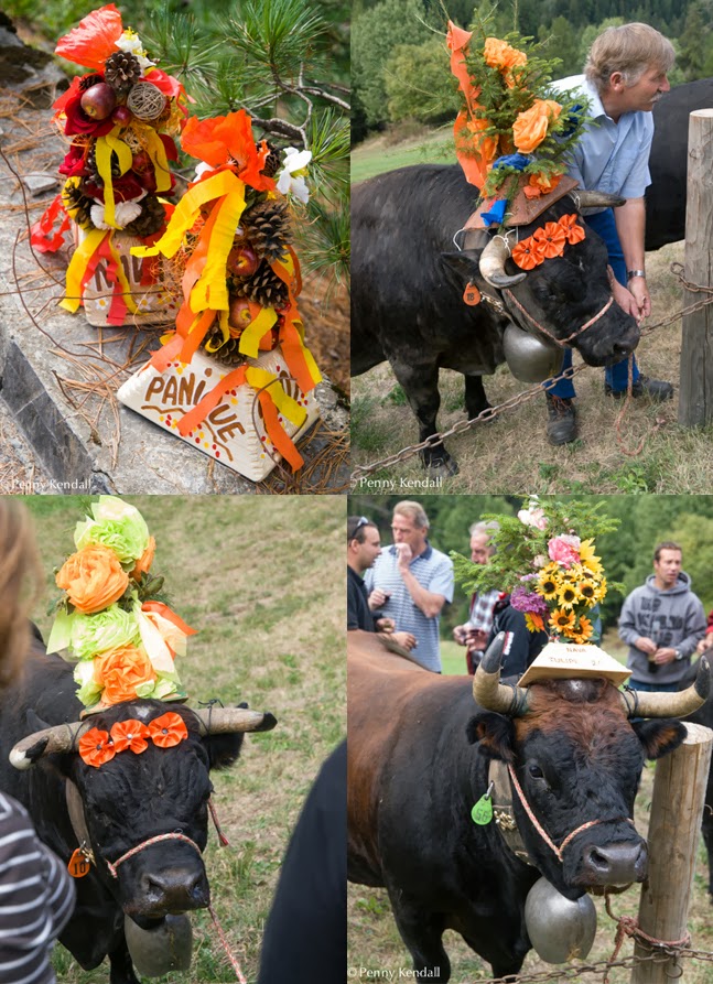
A variety of flower headdresses
Once down headdresses of flowers are tied between the horns in true Valaisanne tradition. Then the parade can begin. Each cow led by it's proud owner through the village - there's clapping for best milker, cheese maker and then the bossiest one (the Queen) whose kept the herd in check. At the end of the village it's time to crack open a few bottles and sample some of the summer cheeses.
Parading through Ayer

Sunday, 19 February 2012

Get your skate skis on...

Skiing downhill is wonderful but not the best for keeping in shape. The answer during the winter months is to do a bit of skate skiing - a fast, dynamic version of cross country skiing. Just an hour and a half from us in Zinal is a mecca for the sport - Goms in the upper Valais.


It's well worth taking a lesson to get to grips with the basic technique. Damian Hischier (in blue, just in case you can't tell the difference between me and him) worked miracles, getting us up and running in no time. He's not quite your standard instructor - in the summer he's not a carpenter but a test pilot...

Damian teaching some tricks to skate skiing.
Just don't over-exert yourself before heading off on one of the wonderful routes that stretch down the valley:
between Oberwald and Niederwald the shortest route is 22km, a journey taking you through ancient villages, across meadows and past chapels. There are lots of alternative trails, twisting and climbing above the valley floor into the forest. But don't forget that what goes up must come down, which is no joke on these skis... There are also plenty of restaurants and bars - some serving the unlikely sounding dish 'cholera' (a sort of Swiss Cornish pastie with onion and apple); and you're never far from a railway station, so when you've had enough (cholera or skate-skiing) you can jump onto a warm train and trundle home. We stayed in the lovely Hotel Tenne, where they serve award winning food and have very comfy beds - perfect after a day's skating.


For our last day we headed down the road to the local downhill ski area of Fiescheralp where we enjoyed the views over the Aletsch glacier and explored with local hero Kilian Volken, a guide who is off to climb K2 this summer. After 30 + years of guiding, it's wonderful to find he's still as keen about skiing the local area, even in perishing cold and with the powder quite wind-blown. One of those inspirational characters you feel better for meeting and a huge pleasure to ski with.

Tuesday, 24 January 2012

All or nothing

Storms hit Switzerland and much of Europe at the beginning of the month.

We went over to St Bernard area to explore some of the little know resorts of La Fouly, Vicheres and Champex Lac, and found some interesting stuff, both resorts and snow. Over there the wind had reached speeds of 270km/per hour. Too strong to form any cornices, it left the tops of the mountains scoured back to rock in places, the snow having been shifted and dropped several meters along where it lay up to 4m deep.

Skiing through the trees was interesting too with the ground littered with large branches and whole trees. Still we found some wonderful stuff - a beautiful and quiet area away from the crowds of Verbier.
Back in Zinal, the tops of the mountains are also back to the rock in places, the first coulour on the Chamois is a boulder field and the top 20m down to the dam is exposed rock and grass. The snow has gone somewhere, the trick is to find out where and access how loaded it is...

Tuesday, 13 September 2011

Tour of the Monte Rosa

Four fantastic days of yomping around the Monte Rosa massif with mad Tom, at speed. It was all his idea - so far he's tackled the tour of Mont Blanc, Corsica's GR20 and Chamonix-Zermatt by the summer haute route, all in a fraction of the normal time, not to mention the Everest marathon, and climbing Mont Blanc with his number 5 ice axe and teeing golf balls off the top.

The tour follows some of the ancient Walser trading routes. We took a handful of pictures with a phone (we travelled very light weight). The normal length of the trip is nine days, and to judge by the straight lines on the GPS routes recorded on the internet, everybody seems to use ski lifts where available, which is an odd way of going for a walk. We didn't.

Vitalstatistics:

  • 4 days
  • over 9200 meters of ascent and descent
  • over 130 km's
  • 1 blister
  • highest point 3302m
  • favourite part (day 2) Colle selle Cime Bianche to Fiery

Day 1 Grachen to Zermatt: along the Europaweg as far as the Europahutte, then on to Zermatt. A beautiful walk with Matterhorn and Weisshorn views, across suspension bridges and rocky slopes. The hut was great for lunch but after that we were forced down to the valley as the high path was closed.

Day 2 Zermatt to Staffal (Italy): up through the not very lovely-to-walk-through Zermatt ski area and over the glacier to the Theodule pass. We pulled on Kahtoola MiroSpikes to give us grip on the ice - these worked impeccably even on the steepest section. Once into Italy and the Cervina side we crossed the rocky moonscape terrain and dropped into the most beautiful valley that followed the Torrent de Courthoud down to Resy -  then up and over the Bettaforca pass to Staffal.

Penny crossing the glacier with Kahtoola MicroSpikes on Scott eRide running shoes
Day 3 Staffal to Macugnaga: up to rifugio Guglielmina then across the Passo del Diavolo and down a rather sketchy footpath, in places very exposed, and into another stunning valley for lunch at Rifugio Crespi Calderini. We were soon climbing again, up and over the most amazing paved footpath: in the 1920's the Alpini (the alpine division of the Italian army) manhandled massive rock slabs to produce a series of switchbacks leading several kilometres over the Colle del Turlo and down the other side. It's an extraordinary piece of engineering which is even marked as a cycle route on our map.

Tom running down from Col del Turlo 
Day 4 Macugnaga to Grachen: Our longest day 13 hours (including a few breaks). Leaving Macugnaga and climbing up to the golden Madonna on the Monte Moro pass you had to remember to cast the occasional glance backwards to the Monte Rosa and it's glaciers. Dawn light spreading over the massive east face was an amazing sight. You must be seeing about 2600 vertical metres of ice and rock wall, and can even make out the crazy Margheria hut lashed to the Gniffeti peak, with steel hawsers, at 4559m.

View back across Macugnaga to Monte Rosa
Leaving Italy is always hard but we pushed on and down the slabs to the Mattmark reservoir, then an easy yomp down to Saas Almagell and a much needed lunch. We headed on to Saas Fee and the start of one of the most challenging parts of the trip: the high footpath back to Grachen is not to be taken lightly. Traversing at about 2300m it is extremely narrow and exposed with massive drops straight down to the valley below. The occasional memorial cross focusses the mind as do the chamois on the path which bound down the slopes at high speed when you appear. It was a relief to turn the corner into the dying rays of the sun and finally descend to where we had started just 4 days and 134 rocky kilometres ago. Not only were my feet and thighs starting to properly ache for the first time during the trip but the route as a whole, and this final leg in particular, was a big enough challenge that we couldn't be sure of making it at the outset. So it was quite chuffing when we did.
Wednesday, 20 July 2011

Himalayan Alps

Despite the mixed weather recently we were able to have a wonderful walk on Monday up the Grand Chavalard with some friends. Despite the cloud swirling around we still got some amazing views down onto the Rhone valley, a vertical drop of about 2400m. It brought back memories of a walk we did in the Langtang in Nepal a couple of years ago (left Switzerland, right Nepal). It's not the first time that we have been reminded of the Himalayas since being here - different cows though...

Gd Chavalard, Switzerland (left), Eric in Langtang, Nepal (right)

On a clear day you would have an amazing 360 which takes in Mt Blanc, the Bernese Oberland and the Matterhorn - something to come back for.